Hong Kong, the amazing city that I call home, has featured in songs from many genres and decades. Over the years I have meant to put together a playlist of songs in which “Hong Kong” features in the lyrics, as a tribute to this amazing city, its history, people and culture. What I really like is the different ways in which Hong Kong is portrayed in the various songs: R&R stop, finance hub, travel stop.
After many false starts, here is that playlist. It’s a short start, but hopefully people will make some suggestions here, which I can add in. I am sure there are a bunch of songs that I have missed out, but these are the ones that come to mind, and the ones I could find online.
Having grown up in Hong Kong, thinking about colonialism and imperialism quickly gives me a headache. At the root of this is an unbridgeable sense of cognitive dissonance: on the one hand these two forces created an amazing city which I love as my home, and on the other I know that using force against others for your own gain is morally reprehensible.
Certain British historians have tried in the past to get around this by claiming that the British Empire was less brutish and more beneficial than other contemporary empires, but this seems to be skirting the issues to reduce collective guilt.
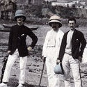
With this personal context in mind, I am immediately interested in any historical images of Hong Kong, especially older ones which might offer insight into what life was like under imperial rule. And so it was that the following image really caught my eye:
Viewing only the top half of the image it seems like some kindly old gentlemen on a rural day out, posing for a photo. Look then at the bottom half and witness beheaded humans lying in the dirt. Should we feel for the “pirates” who have been executed? Did they deserve their fate through wrong deeds, or did they simply upset the wrong imperialists? What are passers-by thinking: are they relieved that justice has been dealt, abhorred by the brutishness of these gwai lo (foreign devils), or fatalistically indifferent?
Of course, we will never really know the answers to these questions, but they are worth discussing all the same. I duly filed the image away for later use, shared it on Twitter and moved on. Much to my surprise, a couple of teachers (@vanweringh and @PaulGrace9) who are now in my PLN saw the image and started sharing and researching ideas on it.
Reading these articles is revealing. It seems like the pirates were genuinely dastardly, but they make up only 6 of the 15 beheadings. Also of interest is that some of the beheadings were carried out by a 15-year old boy. How times have changed.
Our collaboration finished up with suggestions to use HistoryPin and the image below to further explore this area. As was mentioned in our discussions, the topics of piracy and imperialism are so interesting to study as they are still relevant today.
This morning my wife, kids and I took a trip to the Hong Kong Railway Museum, located in Tai Po, just on the edge of the Kowloon-Canton Railway line. Although I pass it twice a day on my way to a from school, it is the kind of place that is easy to overlook and never visit. Mostly outdoors, and lying on and alongside an old segment of track and within an old station, the museum is well worth a visit. By far the best part is getting to board carriages from throughout the 20th century, enjoying a trip back through time to as early as 1911. Looking at how far technology (and our lifestyles as a result) has come in a relatively short space of time is fascinating and would be extremely educational for students of ICT.
Of interest to me from a school point of view are the exhibits on the Fanling-Sha Tau Kok Branch line, a narrow gauge line which ran past the school where I work, ICHK. The green loco in the gallery below is one of the actual trains from this line, and has an interesting life story behind it, having lived outside of HK for 70 years before being returned. Always a remote location, this train line would have brought the outside world to many remote farms and villages, well before a road was built. Some of the images on display (sadly my camera photos were too small to use here) show mountainscapes familiar to me from my daily commute, down to some of the now-abandoned rice terraces.
I would love to see a group of humanities students gather together as much material on this branch line as possible, and find out exactly where it ran in relation to today’s road. Perhaps there are some relics out in the fields and jungle that surround the area.
Continuing this historical theme, it would also be interesting for students to investigate the changing coastline of Hong Kong, and to compare this to previous and current train and road routes. Time Magazine’s Google-powered time lapse satellite imagery could come in handy here, as could some old images, such as the one of Shatin (I believe) below, which seems to show a steam engine at work (top center-right of the image):
Notes & Credits: I am not a train spotter by any means, but as I get older history is becoming ever more interesting to me. I assume that the image above (one of my personal favorites of old Hong Kong) is out of copyright, and sadly do not have credit for it, as I picked it up from the Internet as a teenager (back when I had little respect for copyright). Hong Kong Railway Museum a first-class compartment of 1964 photo by Mk2010 on Wikimedia Commons shared under CC BY-SA, KCR BS locomotive photo by wyliepoon on Flickr shared under CC BY-NC-SA.
It is amazing how one thing leads to another, and all of a sudden you have a crazy idea for a unit of work on your hands. I have recently been watching some video of old Hong Kong, and chatting about the footage with friends and family. My dad and I were wondering where one particular spot was, and threw a couple ideas around. This planted a seed in my mind, and I set out to see if I could use technology to find the answer. It seems that I have actually located the spot, and although it will be at least a few days before I can get out and see for myself, I am 99% certain that it is correct. I am looking forward to shooting some new footage to compare with the original.
Below I will share the steps I took to come to my conclusion, which can be replicated by secondary students relatively easily. The idea for the unit, then, is to give students some old footage and stills from an area they are familiar with (say a city, county, district, etc), and ask them to find as many of the spots as possible. All the confirmed spots can be placed into a Google Map, with the original image, and a link back to where it is found. Students thus build up their own map, putting historical footage in its place, and tying time and space together neatly. They can visit the spots for themselves, and see how they have changed. One of the tricky parts of the process (especially true in Hong Kong) is not only the rapid change of human geography (e.g. new buildings, roads, etc), but also the fact that areas of sea have been reclaimed, and so even large geographical features can change in a relatively short space of time.
I started my investigation by taking 2 screen captures from one particular video, and crudely stitching these together using some graphic editing software (Acorn in my case, as they give it free to schools, but Gimp or Photoshop or a dozen other titles would do). My interest in this spot was first sparked because of the unusual amount of flat land on the right hand side. Click on any of the images to see a full screen version:
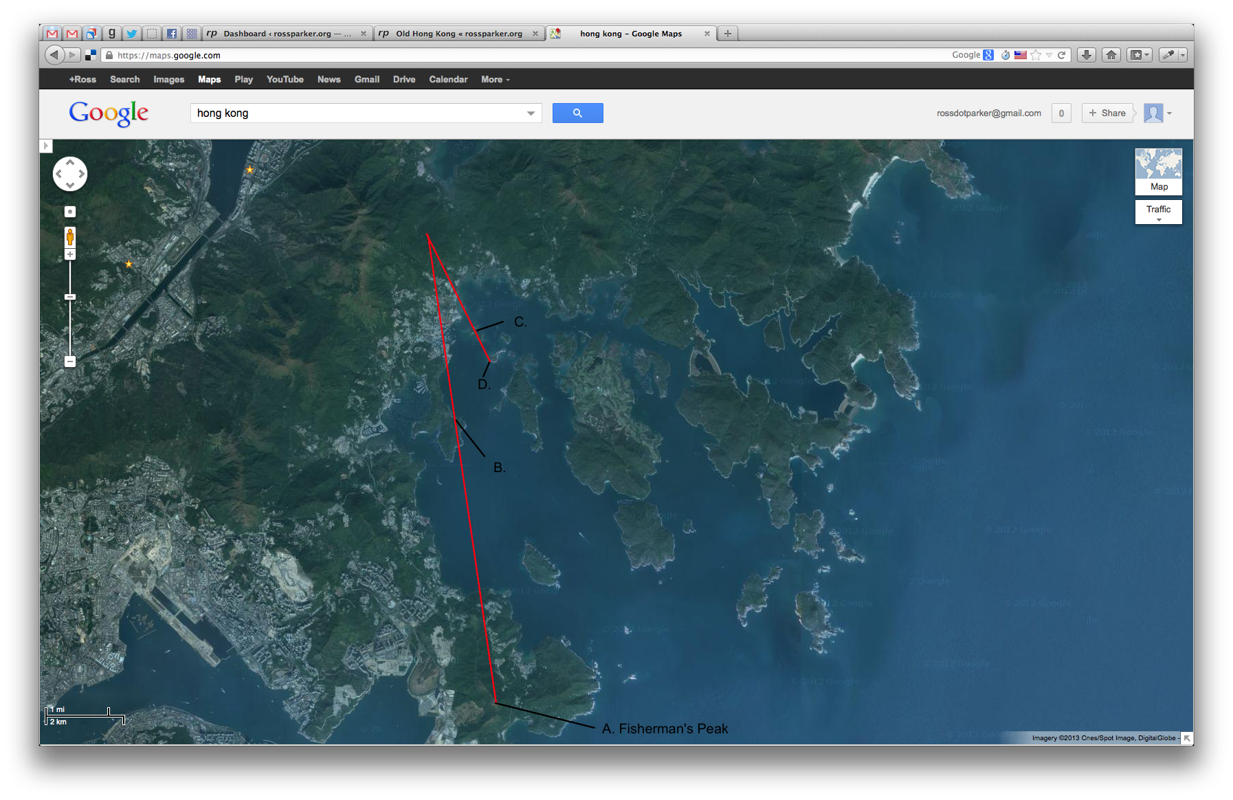
I then searched on Google Maps, looking around Hong Kong to find locations which might be a match. Hong Kong’s numerous small islands and rugged coastline make this quite easy, as there are plenty of features to match. Turns out that my initial guess of near Plover Cove was wrong, and my dad’s of Sai Kung was correct. After making my initial location, I saved a screenshot of the relevant Google Map:
The next step was to search for landmarks along two intersecting lines, in the original image. The trick here was to cross-reference the map and the original image numerous times so as to pick spots which are distinct in both sources. This gave the following annotated version of the original:
These 4 locations could then be marked on the map, and joined by two lines. The point of intersection of the two lines must be where the original image was shot from (I believe this is not triangulation but is similar, although not being a surveyor don’t take my word for it):
Over this I then laid a semi-transparent version of the same map, with labels, so that we can easily identify the surrounding areas.
Turns out that the photo was taken not that far from my house. Closer inspection of the map shows it to be Wong Chuk Yeung, what appears to be an unchanged, traditional Hong Kong village, with some flat grassy land just to the north west. Surely, this must be “the spot”:
Even though I do not teach humanities, I am incredibly excited by this process: it very quickly makes old media viscereal, alive, important. I could literally jump in a car, drive right to this spot and look at the same view that these people enjoyed 50 years ago. What else could we find out using modern technology? Could we discover who these people were, where they lived and why they visited Wong Chuk Yeung on that day. Could we find them? Meet them? Hear their stories? Now, that would be a real history lesson. I wonder if this could be pushed back further in time, with studies performed on paintings left behind by Hong Kong’s first colonial settlers?
My plan is to run this unit with some humanities teachers in my school next year. I would love to see other schools run it, and hear how it went. If only this kind of thing happened more often. It really is the best way to plan a new unit of work.
Update 1 – The Visit
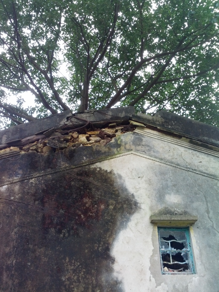
It turns out that my feeling of 99% confidence was 100% wrong: had I consulted an ordinance survey map, or studied the Google Map more closely, I would have seen that Wong Chuk Yeung is in fact on the wrong side of the hill for a view of Sai Kung. That said, the drive up their was more than worth it, as the village is not only huge, but seemingly entirely abandoned. As if stepping back in time, or into a movie set, the area is full of collapsing rice paddies, houses with no roofs, mailboxes stuffed full of mail, and tress growing out of houses:
Wong Chuk Yeung Overflowing Mail
Wong Chuk Yeung Silence
Wong Chuk Yeung Tree in House
Wong Chuk Yeung Ruins
Wong Chuk Yeung Ruins
Wong Chuk Yeung Interior
Wong Chuk Yeung Panorama
The potential for student learning is huge, as are the potential number of questions one could ask of such a place. One of the most amazing aspects of the whole place is finding a large village nestled in a hollow, half way up a mountain: what a defensible, peaceful place, but also, how remote?
Credits: images captured from the original video are copyright Michael Rogge, and used under fair use for educational purposes. Google Maps images are used under fair use for educational purposes.
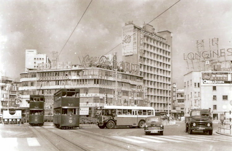
The older I get the more interested I seem to become in the history of the place where I grew up: Hong Kong. Having read a few books on the subject (Hong Kong, History of Hong Kong, Diamond Hill and Gweilo), I am always delighted to find video footage to put images to text. Despite not being born until 1980, I feel a strange affinity for images and footage from the 1950s and before. Recently, my father-in-law (a Hong Konger from way back) shared the presentation below with me, and I thought it was worth sharing:
Whilst searching for an embeddable version of this file online, I also found the videos below, which are very interesting. Sadly, the two best videos, could not be embedded, but you can watch them here and here.
Credits: a big thank you to Michael Rogge for curating and sharing this amazing archival footage. Thumbnail image of Hong Kong by Shizhao on Wikipedia, under Public Domain
Lying to the north of its more illustrious and flashy neighbours Tsim Sha Tsui and Mong Kok, Sham Shui Po is one of Hong Kong’s more traditional districts. Whilst living in SSP in the early 2000’s, I was fortunate enough to have time to explore its myriad streets, and observe all sorts of personal, family and business activities. A quick walk will reveal garment wholesale, electrical workshops, markets, waste processing, computer retail and a host of family-run enterprise, all taking place at ground level.
Of all of the things to see and do in Sham Shui Po, one of the most amazing is the fabric market. Located at the junction of Yen Chow St. and Lai Chi Kok Rd., and housed under the most improbable makeshift roof, this ramshackle market brings together at least 20 sellers of all manner of fabrics. Not only is the range and focus of the stalls amazing, but the owners are all incredibly friendly.
However, the reason for me writing this is not to wax lyrical, or even to offer travel advice, but rather to suggest the following as a task for young maths students to consider: Attempt to estimate, justifying your assumptions, the total mass and length of material available for sale at the fabric market in Sham Shui Po.
I would love to see some answers submitted here. If you students cannot make a visit, I am willing to provide dimensions, number of shops, photos, etc.
Credits: fabric thumbnail by Edal on Wikipedia (CC BY-SA), satellite image of Sham Shui Po by Google (copyrighted, used for educational purposes).
 Having grown up in Hong Kong, thinking about colonialism and imperialism quickly gives me a headache. At the root of this is an unbridgeable sense of cognitive dissonance: on the one hand these two forces created an amazing city which I love as my home, and on the other I know that using force against others for your own gain is morally reprehensible.
 This morning my wife, kids and I took a trip to the


 Lying to the north of its more illustrious and flashy neighbours Tsim Sha Tsui and Mong Kok, Sham Shui Po is one of Hong Kong’s more traditional districts. Whilst living in SSP in the early 2000’s, I was fortunate enough to have time to explore its myriad streets, and observe all sorts of personal, family and business activities. A quick walk will reveal garment wholesale, electrical workshops, markets, waste processing, computer retail and a host of family-run enterprise, all taking place at ground level.